Gifts from the Sea

The U.S. Geological Survey (USGS) has completed the second phase of releasing thousands of photos and videos of the seafloor and coastline through their Coastal and Marine Video and Photography Portal.
Most of these marine and coastal scenes have never been seen before or mapped at this level of detail. A more accurate perspective of these areas helps coastal managers make important decisions that range from protecting habitats to understanding hazards and managing land use.
This USGS portal is unique, due to the sheer quantity and quality of data presented. It is the largest database of its kind, providing detailed and fine-scale representations of the coast and seafloor. The “geospatial context” is also unique, with maps that display imagery in the geographic location where the images were recorded.
Prior to development of the data portal, retrieving this imagery most often required internal USGS access with specific hardware and software. Furthermore, it was difficult to manage and challenging to share such a large amount of information.
During the first phase earlier this year, the USGS published imagery and video of California, Massachusetts, the Gulf of Mexico and the mid-Atlantic coasts. This second phase includes Puget Sound, Hawaii, Alaska, Rhode Island, Connecticut and Long Island Sound, as well as additional products from Massachusetts and nine pre-storm and post hurricane photo datasets from the Gulf and Atlantic Coasts. Video and photographs will be continuously added as they are collected; archived imagery will also be incorporated soon.
In total, approximately 165,500 photographs have been collected as well as 1,210 hours of trackline video covering almost 3,200 miles of coastline.
Dive in and watch tutorials on how to use the portal. Scientists explain the basics of navigating the portal and also show how to search the data catalog and work in the portal with multiple data layers.
Learn more about USGS science by visiting the USGS Coastal and Marine Geology Program website.
In the picture below: This organism forms a colony that is the size of a pin head and can be seen floating in the water. Using ultra violet light, the filaments glow red from chlorophyll, while other pigments give various hues of purple, which may be a hint about the health of the cells.


This photograph of the seafloor off the California coast shows coarse sand, shells and a sunflower sea star. This photograph supports the California Seafloor Mapping Program (CSMP), a cooperative program established in 2007 initiated by state and federal agencies, academia and private industry. Data collected during this project reveal the seafloor offshore of the California coast in unprecedented detail and provide an ecosystem context for the effective management of this precious marine resource. Photo Credit: USGS

This photograph shows three caribou escaping swarms of mosquitos on the mudflats of Kasegaluk Lagoon on the coast of the Chukchi Sea in northwest Alaska. Coastal erosion along the Arctic coast is chronic, widespread and potentially accelerating, posing threats to infrastructure important for defense and energy purposes, natural shoreline habitats and nearby Native communities. To help address these concerns, the USGS is collecting information on past and present shoreline changes along the conterminous United States and parts of Alaska and Hawaii. Photo Credit: Ann Gibbs and Bruce Richmond, USGS

Photograph showing the seafloor off the California coast. This photograph supports the California Seafloor Mapping Program (CSMP), a cooperative program established in 2007 initiated by state and federal agencies, academia and private industry. Data collected during this project reveal the seafloor offshore of the California coast in unprecedented detail and provide an ecosystem context for the effective management of this precious marine resource. Photo Credit: USGS

This photograph of the seafloor off the Massachusetts coast shows a lobster, sponges and brachiopods on cobbles and ledge covered with seaweed, bubblegum algae and red filamentous algae. The photograph was collected as part of USGS research in collaboration with the Massachusetts Office of Coastal Zone Management to support development of the Massachusetts Ocean Management Plan and management of the state’s waters. Photo Credit: USGS

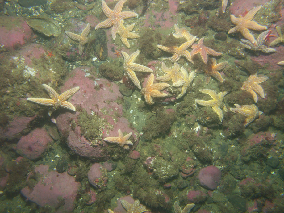
This photograph of the seafloor off the Massachusetts coast shows sea stars, blood stars, blood drop tunicates, mussels and barnacles on cobbles and boulders covered with bubblegum algae and red filamentous algae. The photograph was collected as part of USGS research in collaboration with the Massachusetts Office of Coastal Zone Management to support development of the Massachusetts Ocean Management Plan and management of the state’s waters. Photo Credit: USGS

This oblique aerial photograph of Flaxman Island off the Alaska coast shows tapped thermokarst lakes, caribou tracks and ice-rich bluffs that are eroding. Coastal erosion along the Arctic coast is chronic, widespread and potentially accelerating, posing threats to infrastructure important for defense and energy purposes, natural shoreline habitats and nearby Native communities. To help address these concerns, the USGS is collecting information on past and present shoreline changes along the conterminous United States and parts of Alaska and Hawaii. Photo Credit: Ann Gibbs and Bruce Richmond, USGS

This photograph shows birds taking flight near Icy Cape on the Chukchi Sea coast of Alaska, an area that provides habitat for a variety of avian species. Coastal erosion along the Arctic coast is chronic, widespread and potentially accelerating, posing threats to infrastructure important for defense and energy purposes, natural shoreline habitats and nearby Native communities. To help address these concerns, the USGS is collecting information on past and present shoreline changes along the conterminous United States and parts of Alaska and Hawaii. Photo Credit: Ann Gibbs and Bruce Richmond, USGS

This photograph of the seafloor off the California coast shows rock outcrop, encrusting sponge, cup corals, red sea star and a female kelp greenling. This photograph supports the California Seafloor Mapping Program (CSMP), a cooperative program established in 2007 initiated by state and federal agencies, academia and private industry. Data collected during this project reveal the seafloor offshore of the California coast in unprecedented detail and provide an ecosystem context for the effective management of this precious marine resource. Photo Credit: USGS

This photograph shows snow and ice melt along the rolling hills and coastal bluffs near Cape Sabine on the western Chukchi Sea coast of Alaska. Coastal erosion along the Arctic coast is chronic, widespread and potentially accelerating, posing threats to infrastructure important for defense and energy purposes, natural shoreline habitats and nearby Native communities. To help address these concerns, the USGS is collecting information on past and present shoreline changes along the conterminous United States and parts of Alaska and Hawaii. Photo Credit: Ann Gibbs and Bruce Richmond, USGS

This photograph shows ice-wedge polygons and an eroding shoreline at Cape Halkett on the Beaufort Sea coast of Alaska. Coastal erosion along the Arctic coast is chronic, widespread and potentially accelerating, posing threats to infrastructure important for defense and energy purposes, natural shoreline habitats and nearby Native communities. To help address these concerns, the USGS is collecting information on past and present shoreline changes along the conterminous United States and parts of Alaska and Hawaii. Photo Credit: Ann Gibbs and Bruce Richmond, USGS

This photograph of the seafloor off the California coast shows jellyfish in a water column. This photograph supports the California Seafloor Mapping Program (CSMP), a cooperative program established in 2007 initiated by state and federal agencies, academia and private industry. Data collected during this project reveal the seafloor offshore of the California coast in unprecedented detail and provide an ecosystem context for the effective management of this precious marine resource. Photo Credit: USGS

This photograph of the seafloor off the Massachusetts coast shows sand dollars and a few shell fragments on a sandy seabed. This photograph was collected as part of USGS research in collaboration with the Massachusetts Office of Coastal Zone Management to support development of the Massachusetts Ocean Management Plan and management of the state’s waters. Photo Credit: USGS

This photograph shows two grizzly bears frolic on the tundra near the Avak River on the Chukchi Sea coast of Alaska. Coastal erosion along the Arctic coast is chronic, widespread and potentially accelerating, posing threats to infrastructure important for defense and energy purposes, natural shoreline habitats and nearby Native communities. To help address these concerns, the USGS is collecting information on past and present shoreline changes along the conterminous United States and parts of Alaska and Hawaii. Photo Credit: Ann Gibbs and Bruce Richmond, USGS

This photograph shows USGS scientists collecting data off the Arctic Coastal Plain of northern Alaska. Coastal erosion along the Arctic coast is chronic, widespread and potentially accelerating, posing threats to infrastructure important for defense and energy purposes, natural shoreline habitats and nearby Native communities. To help address these concerns, the USGS is collecting information on past and present shoreline changes along the conterminous United States and parts of Alaska and Hawaii. Photo Credit: Ann Gibbs and Bruce Richmond, USGS

This photograph of the seafloor on the Rhode Island coast shows a skate on a fine-grained, silty or muddy seafloor. This photograph was collected to support research and management activities (e.g., wind farms and fisheries) along the Rhode Island inner continental shelf. Photo Credit: USGS

This photograph of the seafloor in the Woods Hole Passage shows a mussel reef and boring sponge. This photograph was collected as part of the Southeastern Massachusetts Mapping Cooperative between the USGS and the National Oceanic and Atmospheric Administration (NOAA) during a sampling survey of Woods Hole Passage, which is a treacherous waterway with strong tidal currents. Photo Credit: USGS

This photograph of Puget Sound seafloor shows an area mixed with mud, gravel and cobble that is occupied by bivalve mollusks with exposed siphons, a sea star and metridium. This image was collected as part of USGS efforts to help with rockfish recovery in Puget Sound. Scientists are mapping their ecosystem and habitat to understand population distribution. Photo Credit: USGS

This photograph of Puget Sound seafloor shows a sandy area with partial hydroid and algae cover occupied by two sea pens. This image was collected as part of USGS efforts to help with rockfish recovery in Puget Sound. Scientists are mapping their ecosystem and habitat to understand population distribution. Photo Credit: USGS

A polar bear stands on a low-lying barrier shoal near the Huluhula River on the Beaufort Sea coast of Alaska. Coastal erosion along the Arctic coast is chronic, widespread and potentially accelerating, posing threats to infrastructure important for defense and energy purposes, natural shoreline habitats and nearby Native communities. To help address these concerns, the USGS is collecting information on past and present shoreline changes along the conterminous United States and parts of Alaska and Hawaii. Photo Credit: Ann Gibbs and Bruce Richmond, USGS

Coral growth offshore of the Hawaiian Island of Kahoʻolawe has been significantly impacted by the island’s deforestation and resulting erosion and sediment run-off into the nearshore environment. This image shows a coral reef in deeper waters offshore of Kahoʻolawe. Photo Credit: Ann E. Gibbs, Susan A. Cochran, Joshua B. Logan and Eric E. Grossman, USGS.
(This article is published with courtesy: USGS)