U.S.-India Satellite Mission NISAR Launches to Monitor Earth’s Changing Surface

NEW DELHI– In a landmark moment for U.S.-India space cooperation, the NASA-ISRO Synthetic Aperture Radar (NISAR) satellite successfully launched into orbit on Wednesday, beginning a mission that will transform how scientists monitor Earth’s land and ice surfaces.
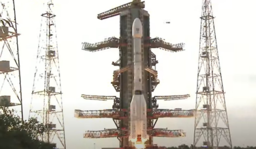
The satellite lifted off at 5:40 p.m. IST aboard India’s GSLV-F16 rocket from the Satish Dhawan Space Centre in Sriharikota, Andhra Pradesh. The mission marks the first time India’s Geosynchronous Satellite Launch Vehicle has been used to insert a payload into a Sun-Synchronous Orbit (SSO).
“We have liftoff! GSLV-F16 has successfully launched with NISAR onboard,” the Indian Space Research Organisation (ISRO) posted on X (formerly Twitter).
“#GSLV-F16 lifts off with the NASA–#ISRO NISAR Earth Observation Satellite,” added Union Minister of State for Science and Technology Jitendra Singh.
Roughly 19 minutes after launch, the rocket is expected to place the 2,392-kilogram satellite into a 743-kilometer sun-synchronous orbit. From this vantage point, NISAR will begin scanning Earth’s surface with unprecedented resolution every 12 days, covering a 242-kilometer swath using advanced SweepSAR technology.
NISAR is the first joint Earth observation mission between NASA and ISRO, representing years of technical collaboration between the two agencies. The $1.5 billion project will deliver continuous, all-weather, day-and-night radar imaging of the planet, revolutionizing global efforts to track environmental change and manage natural disasters.
“Go NISAR! The joint NASA-India satellite aboard @ISRO’s Geosynchronous Launch Vehicle launched from the southeast Indian coast at 8:10 a.m. ET (1210 UTC),” NASA posted on X. “It’s on its mission to monitor Earth’s changing land and ice surfaces.”
ISRO Chairman Dr. V. Narayanan highlighted the satellite’s versatile capabilities, noting that NISAR can detect and map landslides, monitor soil moisture and crop conditions, and assist in climate research and disaster response.
“It can take pictures of Earth 24 hours a day, in all weather conditions,” he said. “This satellite will be a powerful tool for disaster management, climate science, and Earth system monitoring.”
NISAR is the world’s first satellite to use dual-frequency Synthetic Aperture Radar, carrying both L-band and S-band sensors. NASA provided the L-band SAR system, high-speed telecommunications subsystems, GPS receivers, and a 12-meter deployable mesh reflector antenna. ISRO contributed the S-band radar, satellite bus, the GSLV-F16 launch vehicle, and associated ground support and launch services.
Together, these systems will enable the satellite to monitor changes in Earth’s crust, such as those caused by earthquakes, tsunamis, volcanic activity, and landslides. NISAR will also aid in sea ice classification, shoreline monitoring, storm tracking, ship detection, and ecological disturbances.
Beyond its scientific value, the launch reflects growing U.S.-India strategic ties in the space sector. Following a February summit between Prime Minister Narendra Modi and President Donald Trump in Washington, both leaders hailed 2025 as a pivotal year for advancing civil space cooperation.
With NISAR now in orbit, scientists will gain a powerful new vantage point for studying a rapidly changing planet—an achievement underscoring what two leading spacefaring nations can accomplish together. (Source: IANS)