India Maintains Water Advantage Despite China’s Brahmaputra Dam Push

NEW DELHI/BEIJING– As China accelerates plans for its $16.7 billion mega-dam on the Yarlung Tsangpo—known as the Brahmaputra in India—concerns are mounting about the potential downstream impact on both India and Bangladesh. However, a deeper examination of the geography, hydrology, and dam design reveals that India retains significant leverage, and its water security remains largely unaffected.
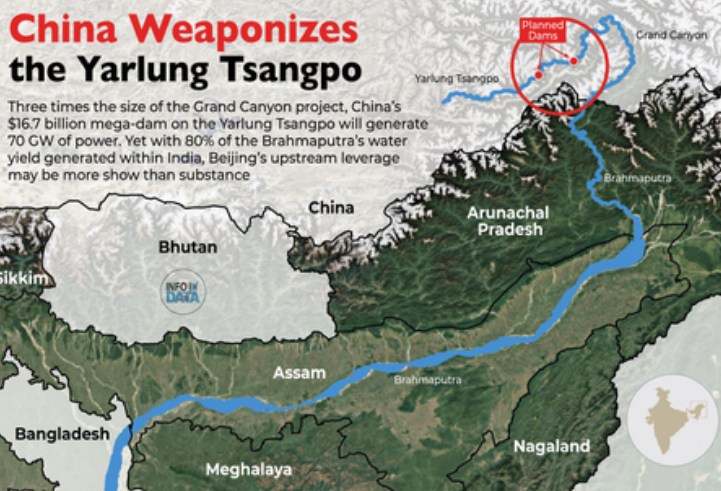
The proposed Medog Hydropower Project, with a projected capacity of 70 gigawatts—more than three times that of China’s Three Gorges Dam—has raised fears of water “weaponization” and upstream control. But experts point out that the realities on the ground tell a different story.
Originating in the glacial regions of western Tibet, the Yarlung Tsangpo flows eastward across the Tibetan Plateau before taking a dramatic U-turn near the Great Bend in Medog (Motuo), Tibet. From there, the river enters India’s Arunachal Pradesh as the Siang, becomes the Brahmaputra as it flows through Assam, and continues into Bangladesh as the Jamuna.
While roughly two-thirds of the Brahmaputra’s basin lies within Chinese-controlled territory, over 80% of the river’s actual water volume is generated within India. The reason? Rainfall. Tibet receives sparse annual precipitation—around 300 mm—whereas Northeast India is drenched by over 2,300 mm annually, with some regions receiving even more. Numerous Indian tributaries and snow-fed rivers further boost the river’s flow, making India the dominant hydrological contributor.
Concerns about China’s intentions center largely on its ability to manipulate water flows via upstream dams. But most of China’s current and planned dams on the Yarlung Tsangpo, including the massive Medog project, are classified as run-of-the-river dams. These structures generate electricity by harnessing the river’s natural flow without creating large reservoirs for water storage.
That technical distinction matters. Run-of-the-river dams cannot significantly disrupt downstream flows over extended periods. While they can temporarily alter water release during electricity generation cycles, they lack the capacity to hold back water on a seasonal or long-term basis. As a result, they offer little utility as geopolitical tools of coercion.
Even local Indian officials are downplaying the threat. Assam Chief Minister Himanta Biswa Sarma dismissed alarmist narratives, likening them to fear tactics used by Pakistan. He noted that even a slight reduction in Brahmaputra flow could help reduce the annual flood devastation that plagues Assam during the monsoon season.
Experts agree that India’s flood problems are primarily caused by torrential local rains and swollen Indian tributaries. In fact, limited upstream regulation might actually help moderate extreme fluctuations—aligning with India’s own plans to build storage and flood-control infrastructure.
While continued vigilance is essential—particularly regarding data sharing and ecological impacts—India’s strategic water position remains robust. Simply put, China cannot easily control a river whose water volume is overwhelmingly determined by rainfall and tributaries within Indian territory.
India’s topographical advantage in the lower basin, combined with the intensity of the Indian monsoon and the number of contributing rivers, ensures that China’s upstream activities offer limited leverage.
Furthermore, any attempt by China to overtly manipulate Brahmaputra’s flow would risk international backlash and diplomatic fallout, especially given Bangladesh’s and India’s shared interest in the river’s health. (Source: IANS)