Coldest blast of the winter thus far to sweep across Northeast

BOSTON–A fresh wave of Arctic air will send the Northeast into a deep freeze through the end of the week and produce some of the lowest temperatures of the winter so far in the region, according to AccuWeahter.
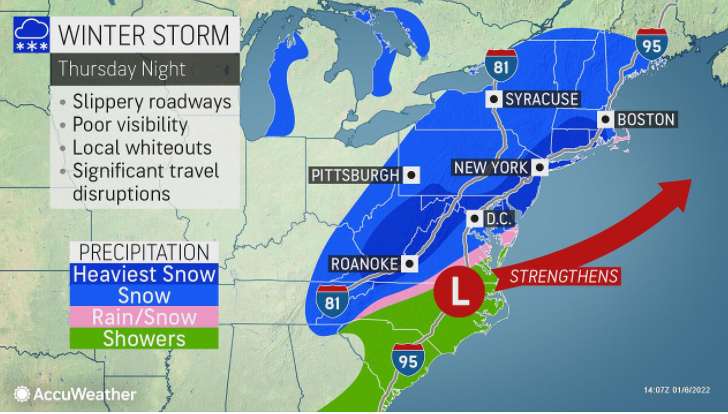
Snow squalls and snow showers will ride in along the frigid winds that will help send temperatures to dangerously low levels. However, forecasters say that the cold air will not be quick to depart and could set the table for a potential blockbuster winter storm in the coming days.
As north to northwesterly winds increase, colder air from Canada was funneled into the Northeast into Thursday night. With a strengthening area of low pressure over the Atlantic Ocean, gusts winds added chill to the air.

The ocean storm will continue to strengthen at the same time, high pressure approaches from the west. The pressure gradient, or difference in pressure values between the high pressure and low pressure, will cause winds to increase further.
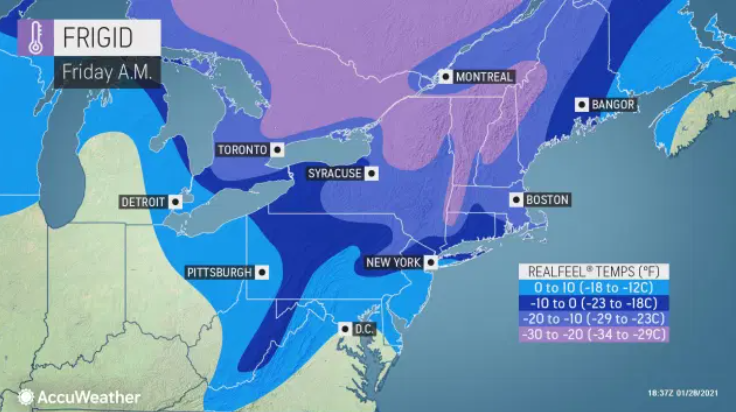
“Thursday night into Friday morning, there will be a biting wind that will make it feel like it’s close to or even below zero at times,” said AccuWeather Senior Meteorologist Carl Babinski.
At 8 a.m. Friday, Boston had a temperature of 7 degrees Fahrenheit. This is the lowest temperature recorded in the city since Jan. 31, 2019, when the mercury hit 5 F, according to the National Weather Service in Boston. The AccuWeather RealFeel® Temperature at 8 a.m. was -22 F.
Besides bringing the cold, these winds will also blow over the Great Lakes. Given the lack of sustained cold so far this winter, there is very little ice over the lakes. Therefore, moisture from the relatively warmer lakes will be picked up, resulting in lake-effect snow.
Following spotty flurries from Thursday, the greatest danger for trouble on the roads occurred Thursday night when snow squalls developed downwind of Lake Huron, Lake Erie and Lake Ontario.
Snow squalls are oftentimes narrow and conditions can change very quickly. Motorists can go from driving in no snow to heavy snow in a short distance. Travelers will need to heed caution along parts of interstates 79, 80, 81, 90 and 99 into Friday morning. Any snow squalls can reduce visibility and cause a quick accumulation on roads.
With the ocean storm slow to move farther away Friday, the brisk winds will continue, especially in New England. In most areas, even where the wind is not as strong, Friday will be the coldest day so far this winter.

“Friday, most daytime temperatures in the region will be no higher than the 20s,” said Babinski. “Temperatures staying in the 20s have not yet happened in New York’s Central Park this season.”
Back on Dec. 16, Central Park reached a high of 31 degrees F. On Friday, the forecast high is only 23 degrees.
Farther north, temperatures may not get out of the single digits in the Adirondack Mountains in upstate New York. That same area is likely to dip below zero Friday night. (Source: AccuWeather)